
 USAID’s Global Development Lab has been the reliable partner of the ASPIRED Project since the very beginning. Lab’s GeoCenter is a valuable source of technical data for the Project, the aim of which is to promote a more balanced and rational use of the groundwater resources of Ararat Valley.
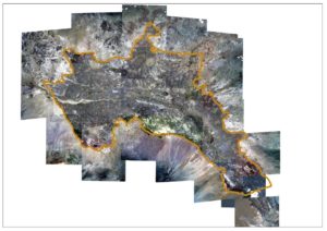
The GeoCenter has recently provided satellite images for the Ararat Valley catchment, covering the territories of Armenia and Turkey. Dating back to summer 2015, the images are of excellent quality and high resolution (3 meters) and will be used by the team for conducting thorough classification of the land cover and land use of the area. The data on actual land use in the valley will further allow estimating the hydrological balance, including water supply and demand balance on the area to be incorporated into a comprehensive Management Information System (MIS) for the Ararat Valley designed by the ASPIRED Project. These analytical tools are important for making informed and rational decisions on use of available water resources of the Ararat Valley.
The Project intends continuing its cooperation with the GeoCenter for receiving similar imagery for the Kars Plateau, which is an important feeding zone for the Ararat Artesian Basin.